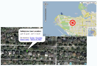
Hardware
Most modern cellular devices are already equipped with the necessary
hardware components to allow for LBS ("Location-Based
Services") locating. The cellular
service providers, however, don't provide an interface to
retrieve and view this location information. This is where
the inDependenceLine system comes in to provide the interface
needed.
Technology
The LBS system will preferentially use GPS satellite locating, for the
most accurate coordinates. If satellite coverage is
unavailable for some reason, the system will automatically
switch over and triangulate your
with near-by cellular towers. As a final backup, proximities
can be given in the case of no satellite coverage and within
range of only one cellular tower.
Pricing
The LBS service is available for a small charge in addition to the basic
monthly inDependenceLine system fee.